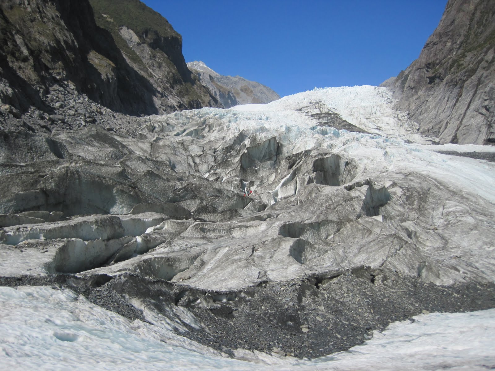
Tuesday, April 26, 2011

On the road to Qtown

Me on top of Queenstown Hill
Kia ora!

The 4.5 hour drive between Punakaiki and Franz Josef  is very nice, mostly following the coastline of the Tasman Sea which separates Australia and NZ.   Pounding surf on one side,  verdant mountainous rainforest on the other.  We passed Lake Brunner, great (and stocked) for trout fishing.  Trout is unavailable commercially.  If you want to eat it, you have to catch it yourself or know a fisher.


Somewhere on the West Coast of NZ
We stopped in Greymouth, the largest town on the West Coast and departure point of the TranzAlpine train that goes over Arthurs Pass to Christchurch, the largest city on the South Island.  Hokitika is a cute little town with  lots of arts and craft galleries where one can take classes in glass blowing, knife making, or pounamu (green jade) or stone carving.  Past Hokitika, the road cuts slightly inland crossing farmland before entering the Southern Alps.


Heading into the Southern Alps 
The Southern Alps are a mountain chain that runs 450 km north to south. The tallest peak is Aoraki/Mount Cook, the highest point in New Zealand at 3,754 meters (12,316  feet) and there are 16 other points in the range that exceed 3,000 meters (9842') in height. The Southern Alps contain more than 3000 glaciers larger than a hectare (2.5 acres).  The longest, Tasman Glacier, is 29 kilometres in length.  Franz Josef Glacier, the one I walked on, is only 12 km long but easily accessible.  These Alps, some with snow year-round, provide the best skiing and snowboarding and since we are in NZ, heli-skiing opportunities in the Southern hemisphere.

Bus stop to look at a waterfall
The Glacier Hot Pools in Franz Josef township consists of 3 rock-edged swimming pools at 36* C,  38* C, and 40* C (97, 100, 104*F respectively) - no jets.  Apparently there are smaller pools available for more intimate gatherings.  Anyway, the middle pool was nice to soak in after my ice adventure.  Supposedly set outdoors amidst a rainforest, with the canopies above and the steam rising into the dimly lit cool night air, I couldn't see much although there were some tree ferns.  It precipitates a lot here, 4800 mm (189" !!!) annual average on 178 days/year, so the canopies are necessary,  but on the short walk back to my hostel, Montrose Backpackers, the stars twinkled brightly in the sky.

Lake Wanaka
On the road again.  This time, the bus leaves at 7:40 am and arrives in Queenstown at 4:15 p.m.  The road twists and turns over and around mountains and valleys.  Some of the mountains have snow on top, most of them are bare or have small shrubs.  One can definitely see the tree line beyond which trees can't grow because of the cold.  It is a beautiful countryside dotted with lakes, webbed with rivers and streams, and accented here and there with waterfalls.  Reminds me of the Sierra Nevadas.  There's gold in them thar hills as well.  New Zealand had a gold rush in the 1860s, the biggest one in the Central Otago area where Queenstown is.

Sailing Lesson on Lake Wanaka
We stopped in Wanaka, a charming town on the shores of its namesake lake.  Wanaka is known as the laid back version of Qtown.  All the adrenaline attractions are available (sometimes at a lower price).  I don't know if it's the broader beach or calmer water, but Wanaka encourages individuals to get on the water and there are paddle boats, wind surfers, and one person sailboats for rent.  Puzzling World is an amusement part with crazy buildings and structures and the Great Maze.  Mount Aspiring (love the name!) National Park offers year round activity.

On the way into town, we pass the Kawarau Bridge where AJ Hackett did the world's first bungy jump in 1988.  His company now offers that 43 meter jump with options for dunking (dry, head, or torso), solo or tandem.  He offers jumps in 2 other locations as well.    Nevis Bungy is highest with 134 meter drop and 8.5 seconds of freefall.  Crazy!!

Lake Wakatipu from top of Gondola Hill
Queenstown's permanent population is 10,500 residents.   With almost 2 million tourists annually, about 50% international visitors, Qtown is the biggest tourist draw in NZ.  The town itself is compact.  The CBD, on relatively level ground and facing Lake Wakatipu, is 3 short blocks by 5 short blocks and crammed with eateries, adventure activity bookers, outdoor gear retailers, souvenir shops, jewellers, and art galleries.  There is one main grocery store and a small Asian grocer and 3 bottle shops (alcohol).

Most of the backpackers hostels are in or within walking distance.  Hotels and motels are within walking distance or further.   Homes are perched on the hills behind the CBD overlooking Lake Wakatipu.  On one side of the CBD is the steep and forested Gondola Hill.  The other side is the main road into and out of Qtown.

So what makes Qtown "the Adventure Capital of the World"?  Here's a list: bungy jumping, luge, paragliding, skydiving, flightseeing, horse riding, canyoning (abseiling is rappelling), zip lines, rope swings, waterfall slides, jet boat rides, river boarding/surfing, jumps into deep pools; wake boarding, water skiing, parasailing, white water rafting, black water rafting (in caves), cycling, mountain biking, 4WD/ATV quad biking (looks like a little tractor), skiing, snowboarding, heli skiing, ice climbing.  You name it, they got it.  For less crazy people there are cruises, coach tours, farm tours, Lord of the Rings film site tours,  and my favorite, tramping tracks.

Steamship TSS Earnslaw

Not all these activities are done in Queenstown.  If you book the activities, a shuttle will pick you up wherever you are and take you to the site which can be up to an hour away.  Most are within a 20 minute drive.  The most visible adventure is the paragliding.  One of the most popular places is off of Gondola Hill.  My hostel, Alpine Lodge, is across from the hill and the landing area for the paragliders.  You can also see some jetboating and parasailing on Lake Wakatipu.

Ready for some action?!  Come to Queenstown!
Cheers!
Jet boating.  What's the thrill?
Cyn

Tuesday, April 19, 2011

Franz Josef Glacier Adventure!

Kia Ora!

The moraine field
From Punakaiki's Pancake Rocks, my journey continues south along the West Coast to Franz  Josef township and Glacier in the Southern Alps.   It is on Franz Josef Glacier that I've had my most satisfying adventure so far.  I booked the Half Day Glacier Experience ($123) with Franz Josef Glacier Guides.  (I think there's only one small competitor.)

Three start times are available;  8:30, 10:30 and 12:30.  I chose the 10:30 am with my friend, Natalie.   The cost includes coach to the glacier carpark (5 km, 2 hour return walk, 10 minute drive, or $12.50 return coach), any necessary equipment, and entry to the Glacier Hot Pools ($23 value).  The Experience should last up to 4.5 hours with up to 2 hours ice time.  Participants should be at least of moderate fitness and agility.

Well, the beginning is a little bit of hurry up and wait.  When you arrive at the shop, you have to fill out and sign a health history release.   But interestingly enough, no waiver of responsibility.  Each person is issued a lanyard with 4 colored cards and an id number.  The brochure tells participants not to carry passports, wallets, room keys, etc.  My joke is that your id number is how they identify you if something happens and you end up a popsicle .  (I took all that stuff in my backpack anyway.)


After a brief intro, we all lined up to exchange a color card for any optional equipment we wanted to borrow.  The morning sky was blue and sunny and the forecast was for good weather all day.   I was already wearing water resistant pants.   I did borrow their thick, Goretex blue raincoats because they said that my raincoat was not thick enough.  They're the experts, I listened.  I did borrow the hats and mittens that were offered cuz I forgot my gloves.  I had been advised to borrow their boots by Mike, my AquaTaxi driver (who also gave my a $5 off voucher (coupon) for this company, because the crampons can ruin your boots.  Everyone got the appropriate size set of crampons in a red fanny pack.

Try to find the tiny chains of glacier walkers
We had 2 Guides (and met a 3rd Guide later) during our Valley Walk which follows the Waiho River bed (2 km?, 20-30 minutes).  One Guide, Caleb, led the way and took us on a "secret Guides' track" that took us through the rainforest. (Yes, there is rainforest right next to the glacier.)  Instead of the fairly level riverbed track, this track was narrow and went up and down and for one short stretch was steep.  When we got to the end of the Valley Walk, he waited a couple of minutes and then said, "Anyone that can hear me say this, you are in Group One."   What?!

That's when I realized that the "secret Guides' track" was how they figured to divide the 43 people into 3 groups.   I was 7th or 8th behind the leader and just kept walking and keeping up because I didn't want to hold anyone up.  I dropped a few steps behind on the uphills but caught up on the down and flats.   No one was on my heels or wanted to pass.  But it was a fast pace and a bit of a struggle.   I laughed and told Caleb that I was going to go slower, take pictures and be in Group 2.

Watch where you step!  This hole's deep!
They assured us that we were all going to have the same amount of "ice time".   Anyway,  they had to ask for 6 volunteers to go up a group.  Even then, Group 3 had 18 people; we had 13 people.  It took us about 15 minutes to traverse the moraine, the chewed up rocky area pushed ahead by the glacier flow and left behind as the glacier retreats.  Then we put  on our crampons and then, FINALLY!! we are on the ice.   By now, it's a little past noon.

It is amazing on the ice!  The ice is transparent, white or "ice blue".  The ice is blue because the rest of the color spectrum is absorbed and all that's left are the blues.   Some of the Glacier appears black from afar because of rock dust.  Rock dust is blown onto the ice and is only a thin covering.  When you are next to it, you can see the ice and the dust rubs off easily (getting your hands dirty).

Franz Josef Glacier
The walking surface looked like packed snow in some places and in others, like crushed ice, and in still others, like solid ice with or without crushed ice on top.  We were told by our Guide, Caleb, to follow wherever he steps, ONLY!  After stepping over/by it, Caleb put his pick axe down where a waterfall ended.  I asked him to do it again so I could take a picture.  He not only did it again but also plunged his bare arm into the frozen water up to his Tshirt sleeve.  And he didn't touch bottom!  Yikes!!    It startled several of us and was a good reminder to walk in his footsteps.

Ice tunnel
While we were often able to use ice steps cut by others before us, Caleb did have to clean them up or cut new ones with his pick axe.  Some steps/climbs were very steep; there were rope handrails that Caleb insisted we use.  Palm up when going downhill.  Palm down going uphill.  Crampons ALWAYS face the direction of travel; do not sidestep.  Sometimes we walked quickly, no time for pix (except stolen hurried shots).  Other times we had to stop and wait for Caleb to scout out the best route before proceeding.

We walked past all sorts of ice formations:  crevasses or cracks huge and small, ledges with steep drops, ice walls with deep holes  at the base, and an area that looked to me like The Emerald City in The Wizard of Oz only it was blue.  We squeezed through valleys of ice so narrow that we were unable to walk erect.  It was easier to slide along the curved wall.  I was thankful for the Goretex jacket and hood.   Walls of ice more than 25' high!  We also went through a tunnel/arch that was about  10' long.  It is indescribable; you have to see it for your self!

Group 1 is in the center of this photo
Other than occasional rope handrails, the only material things we saw were a closed blue barrel (near the waterfall) that was filled with emergency equipment like a tent, blankets, food, extra crampons, etc.  and an open wooden box with shovels and pick axes.  The Guides were in contact with each other with radios about ice conditions at various milestones.  We only saw Group 1 once on our ascent.  We could see other groups below us, especially on our descent.  If you zoom into the pix, you can pick out chains of ice walkers.

I am in awe of how this phenomenal environment is natural, how much ice there was, how it was visiably melting, and here we are walking on it!  With the assistance of the Guide and crampons, I am seeing, touching, walking, and climbing on a massive chunk of ice.   The unknown danger of the ice collapsing under our feet with one wrong step was a thrill.

A crevasse
We spent 3 hours on the ice going more than half way up the long moraine you can see in the pictures.    We went beyond the full waterfall and then stopped below it.  Apparently we went within 400 meters of where the Full day Adventurers normally go.  Unless you are super fit and really like cold, the half day adventure is probably enough.  Especially since we were extremely lucky and had a gorgeous day.  It probably wouldn't have been so fun  nor would we have gone so far if it had been raining or snowing.  We stopped for 10 minutes on the edge of the moraine field to take off our crampons and have a snack.   On the way back through the valley, we visited the three waterfalls of Trident Falls.

The high temperature at the township was about 10*C (41*F); I don't know how cold it was on the glacier.  But the sun was shining and ice was melting.  Really cool!  Maybe dangerous?  Our Guide was in Tshirt and ventilated pants.  But he also had to use his pick axe and he was accustomed to the cold.   I was comfortable in a long sleeved shirt most of the time but put on the jacket to slide along the walls.  Gloves are helpful.  Backpacks are a good idea for water, snacks and to stash extra equipment like your jacket, sweatshirt, hat, gloves, etc.    Side satchels were discouraged because of some narrow passages.

The blue "Emerald City"
Franz Josef Glacier is about 12 km long and sits 300 meters above sea level.  It is part of Westland Tai Poutini National Park and a World Heritage Site.   Glaciers are remnants of the Ice Age.  They can grow when snow and ice accumulation exceeds melt, packs down and freezes.  Franz Josef Glacier has advanced and retreated over the years.  Most recently, there has been a net retreat and is expected to be totally melted within 90 years.  Franz Josef Glacier and Fox Glacier, 20km south, are the most easily accessed large Glaciers in the world.  Less than an hour's walk from your car.  If you have the opportunity, walk on a glacier.  It's even more thrilling than paragliding.  I know, I did that too.  I'll tell you about that soon.


Cheers,
Cyn

PS:  Caleb is taking a one year break from the NZ Army and has been Guiding for 7 months.  His eagle eye picked out a small clear quartz rock (looks like ice!) which he gave to me as a memento.   His mum grew up 300 kms from Franz Josef but his family lives on the North Island and he hasn't Guided any of them.

PPS:  I have used crampons and walked on ice before but I can't remember where and when.  Can anyone remind me?  LOL!  I hate to think that one day, maybe not that far off in the future, I will have forgotten this adventure.  But I probably will.

Thursday, April 14, 2011

Punakaiki, West Coast

Kia Ora!

Natalie, Rachel, Maria, Cyn, Chris
 Have you ever looked closely at a map of New Zealand?  Until I came to NZ, I never had.  It's a small country mostly on two islands with lots of mountains.  And a population of 4.5 million people, most of whom live near the coasts.  So it's understandable that roads are somewhat limited.  Whatever the reason, topography, traffic volume, costs, etc., the highway system for the South Island is essentially one big loop along most of its perimeter.  The circle cuts off 1/6 of the Island, the southwest area of Fiordland National Park but there is one road that leads into Milford Sound.  There's also an Inland Scenic Route that goes from Christchurch pass Mount Cook and into Queenstown.  Queenstown is the only city on the South Island that is not on an ocean coast; it's on the shores of Lake Wakatipu.

One lane only
The 4 1/2 hour drive from Nelson took us from vineyards and forestry plantations to countryside covered with natural bush including lots of ferns on sometimes very steep slopes.  We caught regular glimpses of  the Buller River and eventually passed through the Upper and Lower Buller Gorges.  Since it is Autumn, the river was low but apparently the Buller River has one of the highest flood flows (12 meters/40') of all of NZ rivers.
Highway 6 is the main (only) road on the West Coast. It is one lane each way with a occasional slow car turn-out or even rarer, a passing lane.  We crossed numerous bridges, some of them picturesque.  Most of the bridges are one lane.  That is, if you see another vehicle on or approaching the bridge from the other direction, you wait until they are past and then it is your turn.  No lights or signals, just signs to "Give Way".  There aren't any highways in America where I've seen that.  Even the narrowest areas have the solid line separating the two directions of travel.

After a stop in Murchison, a tiny whitewater rafting town, and Westport, a good-size old gold rush turned coal mining town, we reached Punakaiki, my destination for the night.  Punakaiki is in Paparoa National Park.  While there are limestone caverns to be explored and rainforest tracks to be tramped, the main draws are the Pancake Rocks and the Blowholes.

The Pancake Rocks are sedimentary limestone rock where layers of hard limestone alternate with soft mudstone in a process called stylobedding.  After hundreds of thousand years of weathering, the mudstone has eroded more than the limestone, enhancing the "pancake effect".

The Blowholes are formed by wave action.  These limestone cliffs have been pounded by waves for thousands of years.  Each wave takes away some limestone and eventually caves are formed.  High tide waves surge into the cave and the trapped air and water blow out of cracks and fissures in the cave roofs.  The blows are most spectacular during high tide and high southwesterly winds.  The bus stopped from noon to 12:30 with high tide at 12:10.  Lucky us.

Punakaiki Pancake Rocks
What I like about the tour buses is that they stop for photo ops at the most scenic spots,  even if they are only 1/2 hour apart.  However, I thought that I would need more than the 30 minute stop at Punakaiki so I decided to spend the night at Punakaiki Beach Hostel.  Since there really is only one road that one can travel either clockwise or anti-clockwise, you tend to recognize fellow travellers.  They might be on your bus or on another bus line but you stop at the same places and in small towns, you end up at the same hostel(s).   There were 5 of us that had enjoyed hot chocolate pudding at Tasman Bay Backpackers in Nelson who were spending the night in Punakaiki's only hostel at the beach.

Thar she blows!
Each of us 4 women had at least 2 bags.  A large backpack and a smaller daypack.  Chris, an Englishman, had one medium size backpack.  He didn't have to worry, like me and some of the other girls, about walking the almost 1 km back to the bus stop the next day.  Going to the hostel was fine, it was downhill but....  Anyway, the next morning, I caught a ride back up the hill a couple of hours early and stashed my packs in the cafe while I explored some more.

I attempted to spelunk The Cavern.  There is no info about how extensive the caves are or how they are laid out.   I was too scared to go in very far by myself with only my little torch.  But even when 4 other people came with their torches, it was still too dark and big and echoey.  So I went back up to the Walkway again.


Punakaiki Blowhole
I can watch waves on a beach for hours and this was no exception.  It was fun to watch the waves come in and try to figure out which would produce the largest blows.  The smallest blowhole was more predictable.  You could see the waves come into the gap.  When the water level at the mouth of the cave was covered by water, there would be little or no blow.  If the water was ebbing and the next surge was large, the blow would be big.


For the larger blowhole, it was more difficult to predict.  You could see huge waves crashing into the rocks but only producing small blows.  I learned to listen for the booming sound of big blows instead.  I took lots of pix.  But I missed a shot of the biggest blow.  It really was the biggest one and came out much higher than any other before or after in the 90 minutes I was there and I got DRENCHED.  The third blowhole was mainly a sound one.  It would moan and groan and occasional spit out some spray.

I had fun.
Cheers!
Cyn


BTW, I love digital cameras.  You can take so many pix and then delete the less good ones.  Just as long as the batteries are charged and there's enough memory on the card.
The Cavern

Tuesday, April 12, 2011

Nelson

Kia Ora!

Marae, a Maori meeting house
Back to Nelson.  I stayed at Tasman Bay Backpackers ($24/6 bed).  They served hot chocolate pudding and vanilla ice cream every night at 8 pm.  The line forms at 8 pm and winds through the hostel.  By 8:05 everyone is served and usually the huge roasting pan full of pudding is gone.  The hostel, located a couple of blocks from the middle of the CBD, also has a nice garden.


View from the Centre of NZ


One of the Nelson area's major drawbacks is that public transpo is dismal.  Even the iSites (national Visitor Info Centers) don't know much about the routes or schedules and they certainly don't promote it.  You would think that with 3 national parks and the Mt Richmond Forest Park and hordes of tourists, they could organize a good transpo system.  I would have loved to explore more of the towns near Abel Tasman National Park and the towns in Golden Bay if I didn't have to pay $20 - $100 return fare AND have to spend the night in each town.

Anyway, Nelson's CBD has heaps of restaurants and several arts and crafts shops and galleries, so lots to look at on a rainy day.  But I was lucky and missed all the rain on my walks except the big one at the end of my adventure.   The CBD's nicest feature was the Maitai Riverwalk which follows the river for a kilometer or two.


Chinese courtyard stonework
I also went through several gardens.  The Japanese gardens were very nice with lots of walkways, bridges, and water features.  I went over every path at least twice!   Although the Queens Gardens had several old large trees, the gardens are pretty basic except for the relatively new Chinese gardens where a new bridge is under construction.  The stonework in the Chinese courtyard must have taken a long time to chose and install.  All together, a nice place to stroll and chat with a friend.

The Chinese Gardens
I walked through the Botanical Reserve and tramped up the hill to the Centre of New Zealand.  The actual geographic center of NZ is actually a few kilometers away from the celebrated site, but who's measuring?  I was not impressed by the Nelson Provincial Museum, a little too provincial.
The Japanese Gardens

That's about it for Nelson.
Cheers!
Cyn

Sunday, April 10, 2011

Tramping Abel Tasman

Kia Ora!

Cool Bridge in the Rainforest
Nelson is in the northwest area of NZ's South Island, east of Cook Strait.  Nelson's biggest draw is its 3 national parks.  Kahurangi National Park, right next door, is the second largest and newest of NZ's 14 national parks. Nelson Lakes National Park, sculpted by glaciers, is to the south.  But Abel Tasman National Park, NZ's smallest, is the most visited.   The area is subtropical rainforest on a granitic rock base.  The Abel Tasman Coastal Track is 52 km long, usually takes 3 days to tramp, and winds over the coastline around golden beaches and through dense rainforests.  BTW, hiking is called tramping in New Zealand.


Gray and pied cormorants
One of the drawbacks of Abel Tasman, or maybe its saving grace, is that most of it is not accessible by car.  Most people access the park from the south at Marahau or Kaiteriteri from Nelson (1 hour drive) or Motueka (15 minutes drive). There is also western access from Takaka at Totaranui.  There are no shops in the park other than a cafe at the Awaroa Lodge which is accessible only by tramping or water taxi.  Potable water is available only at 4 sites along the track.  There are also 4 huts and camping facilities for overnight use by registered guests.

Split Apple Rock
Of course there is a solution for this inaccessibility.  Good ol' capitalism.  There are several companies that offer water taxi service.  They offer many options.  Coach from Nelson or Motueka, then water taxi from Kaiteriteri or Marahau to your desired bay.  From there, you can tramp back to Marahau and civilization or tramp back to a predetermined bay and reboard the water taxi back to Marahau. Alternatives include kayaking, either guided or unguided.  Of course there are options for that as well, including overnight, tramping, cruise, and kayaking combos.

I chose Abel Tasman AquaTaxi's most popular package, Seals and Sand, ($70 + $18 return coach to Nelson) so that we could cruise by Tonga Island and view the seal colony before getting set down at Onetahuti Beach for a 13.8+ km (8.3 miles) tramp back to Torrent or Anchorage Bay for a water taxi pickup.  I asked Mike, my taxi skipper, if people (me) could get picked up at Bark Bay if the going got too tough.  I wasn't sure what kind of terrain I would have to tramp through and the forecast was for showers in the morning with rain by afternoon.  I was assured that Grandma could do this in a wheelchair.  (NZ grandmas must be pretty hardy; that's all I can say.)  His answer was yes, just wave them down using very big arm movements otherwise they'll just think we're being friendly.

Torrent Bay and Village- see how high the water is at 10 am
Abel Tasman Park has an unusually wide tidal range where there can be 5.2 meters (16 feet) difference between high and low tide.  Several areas of the track have high or low tide alternatives.  Mike told us that the day's tidal range was about 4 meters and low tide would be at 2 pm.  Our scheduled pick up was 4 pm at Torrent Bay or 4:15 at Anchorage Bay.

New Zealand fur seals and pups

My adventure started with a 7:30 am pick-up from my hostel.   After check in, we boarded the water taxi in the parking lot.  A tractor pulled us to the boat ramp and then we were off!  There was a stiff wind so the water was a little choppy.  Mike decided to give us a thrill by going fast through the swells.  It was a roller coaster ride with the boat airborne at times.  We slowed down to see the pied and gray cormorants (known by locals as shags) on the shore and Split Apple Rock (in water at this point).  We also got 2 stories about how the rock was split, the Maori story and the geologic story.

Tonga Bay where we were set down
We cruised (at high speed and very bumpily) to Anchorage Bay to set a passenger down.  This is a water taxi setting down on a beach.  None of us had realized that we had to take our shoes off and roll up our pants.  Most people got their pants wet either from splashing or their pant leg falling down.  I guess it wouldn't really matter anyway since it was raining on and off,  but we were protected by the roof and sides of the taxi and were dry at this point.

We passed Torrent Bay and Torrent Bay Village.  The Village is private property dating to before Abel Tasman was a national park.  The small home on the far left sold in 2009 for NZ$1.3 million; a house like that would normally sell for $300,000.  A mere $1 million for location, location, location.  Most of the homeowners have boats; a few have helicopters.  Then off to Bark Bay where we set down more trampers.  Then we sailed to Tonga Island to view the seal colony up close.  There were lots of NZ fur seals and their pups lounging on the rocks.  Darling little things!

We arrived at Tonga/Onetahuti Beach at 10:15 am.  Since we had to deliver 2 kayaks and a guide to overnight trampers, they beached the boat.  Jumping from the gangway, we didn't get our shoes wet.  There were 5 of us.  A British couple, a couple from Long Beach, California and me.  And that was the order in which we entered the bush.  We tramped for a little while and came out to the next beach, Tonga Quarry.  Then the British couple took off and we never saw them again.  (They got picked up at 2:45 pm.  They did 15 km in a total of 4.5 hours!)

Bark Bay estuary still under water at noon - go around!
The Long Beach couple and I leap frogged each other because of steep inclines and photo ops.  (I can do uphills much faster than a few years ago since I've been training.)  I also took a low tide track and had to double back when I found the beach still inundated.  I thought since it was only 2 hours from low tide, the water should have receded sufficiently.  (I learned about tides during my Marine Biology class last year.)  Not here!  Anyway, it took almost the predicted 2 hours to walk the 6.1 km to Bark Bay.  While I was there, a ranger told me that low tide was at 3:50 pm and that's why the waters were still high.
After a 45 minute lunch break and to let the water recede enough to walk over the beach, I continued tramping.  The scenery is terrific.  Tropical rainforest with lots of ferns and tree ferns.  And lots of other plants most of which I could not positively identify.  Lots of little bridges and then a long swing bridge!  Thank goodness it wasn't very high.  If it broke, I could probably survive the fall, especially since it was low tide.  At times the track is very steep; at times it is very densely forested.  Sometimes it is a little spooky.  Occasionally it showered but the rain held off.  It took about 2 hours to tramp the 7.7 km.  I picked up the pace a little because the skies were looking ominous and I wanted to beat the rain.
Torrent Bay 2pm  - I can see where I was supposed to go

Since I got to Torrent Bay before 3 pm and the water taxi wasn't coming till 4 pm, I decided to tramp to Anchorage Bay.  I figured that I could take the beach route since it was almost peak low tide.  It was only .9 km and "should take 20 minutes" across the beach.  Well, it started to rain but I continued.  Then I saw that I would have to do some wading so I took off my boots and put my socks into my pockets.  Then it started pouring!


Yeah, it's low tide, just not low enough for me
I was getting totally soaked because the wind was whipping the rain everywhere.  I put my boots back on cuz walking on the shells hurt my feet.  Visibility was really poor.  Still I kept going towards the marker I could see and trying to find the most shallow areas, less than calf deep.  But by 3:20 I still couldn't see the opening that was supposed to be between the stranded island and the mainland.  Then thunder!  Yikes!  Forget it.  I'm going back to Torrent Bay so I can be there by 4 pm.  Then lightning!!  Yikes!!  I started running!  Then I see the Long Beach couple with their shoes off standing by the water.  They saw me coming back and saw the lightning and me running and decided not to go any further.

None of us knew when low tide was; we had been told 2 pm, 3:50 pm, and 4:30 pm.  I guess it didn't matter, you might have to do some wading anyway.  I waded through the water in my boots; they were wet anyway from the rain, what's a little salt gonna do to 'em?  So we tramped back to the meeting point at Torrent Bay.  We walked out to the shallows which were a very long way from where we had been just 6 hours previously. We saw two other taxi services but not ours.

Can you believe this?!
Finally, at around 4:15, we see what should be our taxi coming and I do the big arm wave, just in case.  Mike, funny guy, veers off as if going away from shore.  Well, the rain is pouring down, the bay is choppy and he can't get the boat in any closer.  We have to wade in past our knees to the gangway.  It doesn't matter about getting wet at this point; I'm soaked through everywhere.  But I really don't like water, especially waves or deep water.   I had an adventure!  Beautiful, calm, and enjoyable and then wham!  Well, at least the rain held off until 3 pm.  It coulda been worse; we coulda had to tramp all day in the rain.

It was a great day.
Cheers!
Cyn