 |
| Uluru waterfalls! |
G'day!
Probably everyone has heard of Ayers Rock now known by its Aboriginal name Uluru. But most of the tours offered are for 3 days to Uluru/Kata Tjuta/Kings Canyon. I had never heard of the other 2 places but they must be grouped for a reason. So I booked my tour with The Rock Tour for $355 (all inclusive).
I was picked up just after 6 am in front of my hostel, Alice Lodge Backpackers (no incidents this time). An hour later, we headed south on the Stuart Highway. Uluru-Kata Tjuta National Park is 450 km/270 miles from Alice Springs so much of the first and last day is spent traveling on the Stuart Highway. We stopped in Curtin Springs to buy beer since alcohol is unavailable in the park and stopped along the Highway to pick up firewood.
 |
| The many heads of Kata Tjuta |
We had to drop 7 of our passengers off at Yulara because Tiger was grounded while they were on their Rock Tour and they had to scramble for new itineraries. We picked up 2 passengers for our tour so our final number was 10 guests. Rachelle was our intrepid guide. My tour mates were Christine and her sons Andrew (26) and David (13) from Melbourne, Elizabeth (Irish), David (British Israeli) and 2 pairs of French girls (all mid - late 20s).
 |
| View from Karingana, the second Kata Tjuta overlook |
Tjukurpa is the Anangu story of creation that is taught and remembered through songs, stories, dances, rock art, and objects to the right people. Some of this knowledge are rituals for men only or for women only; some are only for those who inherited the right to the knowledge or earned it. Kata Tjuta is a sacred place for Anangu men and none of its creation stories are shared.
 |
| We had to climb this smooth slippery area - good thing it wasn't wet |
Our first stop was Kata Tjuta or The Olgas after the tallest mountain (1066 meters/3500') in the group. Kata Tjuta means "many heads" in the Pitjantjatjara language, an apt description of the 36 steep dome-shaped rock formations. Kata Tjuta is of sedimentary conglomerate rock held together with sandstone and the weathering has made the area unusual.
 |
| Looking back from Karingana |
We went to the Uluru tourbus sunset viewing area. The area is between Kata Tjuta and Uluru (25 km/16 miles apart) and the sun sets behind Kata Tjuta. What we are meant to see is the reflection of the sunset off of Uluru. To really see the sunrise/set color effect, I think one needs to be closer to the rock than we were.
 |
| Can you see an elephant? |
Ayers Rock Campground is equipped with hot showers and toilets but the lights in the women's side didn't work (same thing at Kakadu - interesting). And it was COLD so most of us stayed "grotty" (grotesque) and "manky" (stinky?) the whole time.
 |
| Sunrise: Uluru is to the right |
We slept under the stars in a circle around the campfire. Too cold for mossies. I got teased because my sleeping bag from home is rated to 20*F/-6.5*C. (Thanks to shoulder season high altitude Utah camping - too hot and crowded in summer.)
 |
| The Rock Tour bus |
Rise and shine at 6 am to roll our swags tight and break camp to go see the sunrise by Uluru. We went back to the sunset viewing area, saw the sun rise next to Uluru, and enjoyed the brilliant colors in the sky.
 |
| The Anangu, "Don't climb Uluru." |
While visitors are allowed to walk all around the base of Uluru, there are several reasons why they are discouraged to climb Uluru. The most important reason, for me, is that it is a sacred place for the Anangu and they don't want anyone to climb it. They have decided to lead by example and no longer do their ritual climbs.
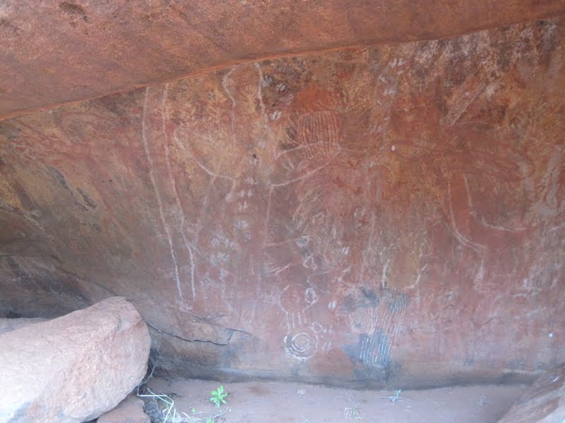 |
| Uluru rock art |
And if those reasons are not enough, at least 35 people have died while attempting the dangerous climb. Apparently the most accessible place to climb Uluru is on the western face. A knee-high post and chain line on part of the face is visible from the carpark. That's only 1/3 of the climb. The climb is closed during adverse weather conditions and for important cultural reasons.
 |
| Doesn't the pattern on the far left look like a brain? |
A ranger-guided walk (included in $25 park entry fee) that teaches about Anangu culture and the significance of Uluru is available daily at the Mala Carpark. But we had Rachelle who told us everything we needed and wanted to know. I am impressed with the professionalism of Aussie tour guides. Tourism is big business and the guides really know their stuff.
 |
| Lungkata, the blue tongue lizard man |
One Tjukurpa story is about Lungkata, the blue-tongue lizard man. Lungkata, while hunting around the southern base of Uluru, killed an emu that others had speared and started cooking it. He hides the emu meat and lies to the two hunters when they see his fire and confront him, saying that he has not seen the emu.
The two hunters find and read the tracks, deduce what has happened, and go after Lungkata. Lungkata gathers up the meat and runs up towards his camp, a cave up on the western face, dropping chunks in his rush. But Lungkata is soon caught and burned in a huge bonfire. The smoke and ash still stain the side of the rock (it is very clear and IS in the shape of a lizard), the emu's thigh is visible closeby, and the boulders below are chunks of emu meat. So the Lungkata story also teaches against lying and stealing.

The Mala Walk is probably the most popular walk because of easy access to one of the two waterholes at Uluru, rock art, and caves and rock formations whose creation story is allowed to be widely shared.
After Rachelle gave us our interpretive Mala Walk (2 hours) we finished the Uluru Base Walk, a 10.6 km/6.4 miles loop (another 2 hours). During our walk, it sprinkled on and off; the downpour began just after most of us had returned to the minibus.
 After lunch, we visited the Cultural Centre for an hour. Heaps of information on history, kinship and relationship, geology, land management, weather, food and medicinal uses of flora, fauna and insects, arts and crafts, the "sorry book", and more.
 |
| The footprint of Lira, the poisonous snake made during the battle with Kuriya, the woma python |
Uluru is an Australian icon and deservedly. Kata Tjuta is just as deserving but how many icons can a nation have. But because of its proximity to Uluru, hopefully most visitors will also enjoy Kata Tjuta. You'll get the rest of my adventure next time.
Cheers!
Cyn
No comments:
Post a Comment
Thanks for your comment. Gday!